
Company info:
Name: Wegoto
Date founded: 2015
Number of employees: 3
Location: Montbonnot St-Martin (France)
Wegoto develops solutions to capture geographic data in the field & connect geographic information systems (GIS) to a multimodal mobility platform, for real time data update and dissemination.
Partners:

Innovation Management Partner:

Real-Time 3D scanning system for Accessibility diagnosis
in urban environments
Challenge
Digital 3D city maps are useful for many applications, for instance, urban planning, emergency response simulation, virtual tourism and illustration of historical buildings, route planning, accessibility analysis for different types of mobility and profiles. Basically, different types of maps can be created, depending on the application requirements. The main acquisition techniques that can be found in the literature are either highly time consuming (with many manual post-treatment to build the 3D map) or they are highly computational demanding (with off-line treatment of the raw data and large memory storage) while the spatial resolution might be not sufficient for the targeted application.
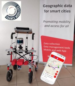
Thanks to the project CADIX, Wegoto developped an integrated system that complements today Wegoto LabTrack, a trolley designed to collect data in pathways to later perform accessibility analysis and route planning for people with different profiles and (dis)abilities in the context of soft mobility.
Solution
CADIX captures at low cost 3D data from different range sensors. These data are fused in real-time, leading to a compact source of 3D information. The LabTrack-CADIX solution is a hybrid measurement system with cameras, telemeters, Time-of-Flight sensors, LiDAR together with GPS localisation of the obstacles present in the pathway. This LabTrack-CADIX solution extends the current database with “safety cocoon” information, i.e. information regarding a safe volume defined around the LabTrack.
FED4SAE Support
Wegoto business model is based on collecting and disseminating urban geographic data. FED4SAE allows Wegoto to access CEA support to revisit the architecture (hardware and software) of the LabTrack, taking into account sensor characteristics, computing and memory needs and ease the integration of an encoded wheel that triggers data acquisition every time the LabTrack travels 1m. Thanks to CEA expertise, CADIX firmware was developed using ROS (Robot Operating System) and integrating SigmaFusion™ to fuse data in 3D from the different range sensing technologies, i.e. LiDAR, stereo camera and Time-of-Flight sensors (from STM) acquired through a STM32 platform, provided to the project by STM. Tests have been conducted with the prototype in laboratory environment and in CEA “mini smart village” that mimics a (simplified) urban environment with poles, parking barrier, traffic signs, buildings, pedestrian pathway. Then, the LabTrack-CADIX system will be validated tests in real-life environments.
Impact
Wegoto is currently accelerating its development and in search for financing to sustain its business roadmap. Wegoto will continue to invest in R&D activities to improve the LabtTrack by with another range sensing technology, able to offer the same measurement precision, but with a smaller range (a few meters is enough), and at low cost, accelerate and increase its data collection speed. The CADIX project is fully part of Wegoto corporate strategy and complementary to future envisaged projects, in particular in the field of imaging.